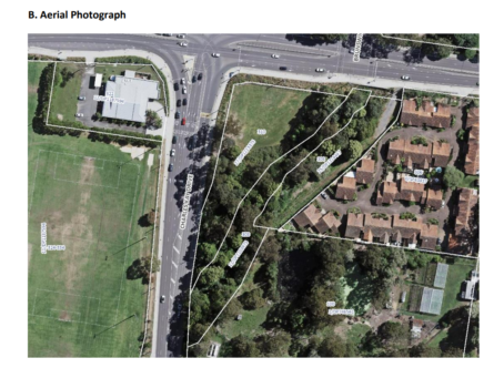
A six storey development at Terrigal could go ahead if the Administrator starts the process to amend the maximum height of buildings allowed on the corner of Terrigal Drive and Charles Kay Drive.
Currently now only 8.5m, or two storeys generally, the rezoning would lift it to 25m to allow six storeys.
The Local Planning Panel looked at the same proposal but with a height of 32m and considered the proposal did not have strategic or site-specific merit.
Now the proposal has been amended to a 25m building with retail limited to 150m2 on the ground floor.
Council-under-administration is calling the proposal on currently vacant land a “gateway development” that would “uplift residential development potential” in Terrigal.
Issues with the site include:
# Flood risk
# traffic management
# protection of riparian zone
“The site is already zoned for residential use, however the developable area is constrained due to the location of a riparian zone along the 3rd order stream to the south-east of the site,” the report to the Administrator states.
“Due to site characteristics, the developable area is limited and therefore has been strategically positioned to ensure minimal environmental impacts in relation to traffic and transport, flooding and biodiversity.”
The Environmental Assessment identified that 3,000m2 of native vegetation would be required to be cleared for the development, with about 15 of 200 trees requiring removal.
“This includes cleared land containing exotic vegetation and a small area of low-quality Narrabeen Coastal Blackbutt Forest (approximately 753m2 ),” the report states.
“A hollow-bearing tree identified on the site is also proposed to be cleared.
“Mitigation measures have been identified in the Environmental Assessment to reduce indirect impacts to biodiversity values of the site.
“Assessments of significance were conducted for the threatened flora and fauna species detected on the site, which concluded that the proposal would not result in a significant impact.”
On the flood issue:
The site is flood affected, with peak 1% Annual Exceedance Probability (AEP) flood depths varying across the site.
Towards the creek and within the site, peak 1% AEP flood depths reach 1.5 metres.
In the vicinity of the site where the development is proposed, 1% AEP flood depths range from 400mm to 900mm.
In the Probable Maximum Flood (PMF) event, flood depths range from 1,600mm to 2,500mm where the development is proposed.
“The impacts resulting from the proposed development are generally isolated to the subject site or the adjoining RE1 zoned watercourse,” the report states.
“There is a minor 12mm increase in peak flood surface levels adjacent to Terrigal Drive, however this does not affect the trafficability of Terrigal Drive and only exceeds the Central Coast Development Control Plan 2022 threshold for a few minutes.
“This was considered acceptable by Council’s Development Flooding Engineer.”
Further studies assessing the impact of climate change-induced rainfall intensity are being undertaken.
On the Traffic:
Key intersections at Terrigal Drive and Charles Kay Drive, and Charles Kay Drive and Scenic Highway currently operate well, with low average delays, according to the report.
While it says the intersection of Charles Kay Drive and Scenic Highway operates near capacity and will need an upgrade “at some point in the future” the report states that modelling indicates that the proposal would have no significant impact on the future operation of these intersections.
The proposal will be dealt with at the March 26 meeting: (Yikes! That’s tomorrow night already…….)
If, as is the norm, the Administrator adopts the staff recommendation to adopt the proposal, it will come back to the public for community input after a gateway determination from the State Minister for Planning.


What is going to happen with traffic during peak hour. Morning traffic is a nightmare. It is hard enough now trying to turn right from Duffys Rd onto Terrigal Drive. Traffic from Terrigal to Erina is at a standstill