The Northern Lakes Floodplain Risk Management Study and Plan (FRMS and FRMP) is expected to be adopted at the October 11 meeting of Council-under-administration.
Proposed actions in the plan include Improving the flood warning system.
For example, the Toukley rain gauge could issue email/SMS alerts when rain triggers are reached.
Culvert upgrades at Greenacre Avenue Lake Munmorah and Crossingham Street Canton Beach and Lett Street between Gorokan and Tuggerah Lake are a high priority as is excavation of the Woodlands Parkway reserve entrance.
If adopted, Council will review and adopt revised flood risk management provisions in the Central Coast development control plan (DCP) for the area.
Flood education is also a high priority.
This includes displays modelling flood appropriate messaging; developing an accessible flood emergency plan template; installing signage at flood prone carparks and installing flood depth indicators at low points on roads.
In the medium-term Council wants to prepare “dam break” analysis for Gorokan Park basin and the sports fields directly east of Lakehaven shopping Centre.
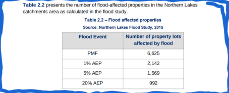
The plan includes a definition of the flood problem by assessment of building inundation, road inundation, emergency response classifications and flood damages.
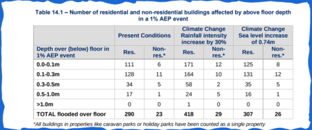
About 290 dwellings and 23 businesses would be flooded above floor in a 1% AEP (annual exeedance probability) event, though generally to shallow depths (239 residential and 11 commercial are flooded by less than 300 mm).
The estimated average annual damages is $7.1 million and the net present value of damage is $105.7 million catastropic damage to houses is largely confined to very rare events (medium risk) but moderate damage is expected in frequent events (high risk).
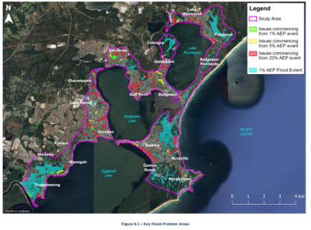
Areas of pronounced risk in the study area include Gascoigne Rd and Lett St in Gorokan, Karangal Cres in Buff Point, and the back of the dune at Canton Beach.

Public exhibition
The draft FRMS/P were placed on public exhibition for four weeks in February 2021 and earlier, in August 2018, a total of 4948 letters were distributed to all property owners.
The letter alerted the residents and businesses of the online survey that was available to complete.
Council said a total of 462 responses were received.
“This represents a response rate of 9.3%,” Council said.
“A total of 19 responses were provided using the online Floodengage and 443 hardcopy responses were submitted.”
Study Area
The Northern Lakes includes the local catchments surrounding Lake Munmorah, Budgewoi Lake and the northern half of Tuggerah Lake.
The objective of the project was to undertake a Floodplain Risk Management Study and to develop a Floodplain Risk Management Plan for the Northern Lakes catchment focusing on overland flooding.
Mainstream flooding generated by elevated levels in the lakes was not part of this study.
(The current Tuggerah Lakes FRMSP focused on the lake (mainstream) flooding generated by Budgewoi Lake, Lake Munmorah and Tuggerah Lake.)
The Northern Lakes catchments occupy a combined area of 33.5km2.
The study area comprises a number of suburbs that surround the inter-connected Lake Munmorah, Budgewoi Lake and Tuggerah Lake system; namely Wyongah, Gorokan, Lake Haven, Charmhaven, San Remo, Buff Point, Budgewoi, Halekulani, Lake Munmorah, Noraville, Toukley and Norah Head.
The downstream areas of the catchment are impacted by flooding from Tuggerah Lakes.
The capital cost of implementing the flood modification options within the Northern Lakes FRMSP is $4.1M.
Should the Northern Lakes FRMSP be adopted by Council, the recommended actions identified within it become eligible for NSW Government grant funding.
Mitigation works can be ranked against other mitigation works across Council’s Long Term Financial Plan to justify the works to be included in the Delivery Program and Operational Plan depending on the nature of the works, the report to the council meeting states.
The study and the complete list of recommended actions is listed in the agenda and attachments for the October 11 meeting.


You may want to review your markings for San Remo, has anyone actually been to these sites?
Your marking are for high areas over 100m higher than the lake levels, IT WILL NEVER FLOOD, Its ridiculous they’re marked..