UPDATE: Rezoning has now been finalised, according to a press release from Member for Terrigal Adam Crouch on December 9, 2022.
The press release also quoted Minister for Planning and Minister for Homes Anthony Roberts who said the NSW Government had
given five rezoning proposals the green light to boost housing supply from Doyalson to Chain Valley Bay.
given five rezoning proposals the green light to boost housing supply from Doyalson to Chain Valley Bay.
Development applications are required to be lodged before construction can begin.
Original post from October 9.
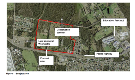
Public comment on a rezoning proposal for land at 285 – 335 Pacific Highway, Lake Munmorah, closes this Friday, October 14 at 5pm.
The rezoning of the 27 hectare site would eventually see the land subdivided into about 300 house blocks with minimum lot sizes of 450m2.
The land is to be rezoned from RU6 Transition to R2 Low Density Residential and E2 Conservation.
The rezoning first came to Council in 2019 and is now in the final stages before approval.
The site is visible from the Pacific Highway, and adjacent to the Lake Munmorah Shopping Centre that is located on the corner of Tall Timbers Road and Pacific Highway, Lake Munmorah.
An area of public recreation land to the west of the site acts as a buffer between the existing residential development at Chisholm and Deakin Avenues.
To the north is a large, heavily vegetated site and the Pacific Highway is the Southern boundary.
Currently the land is six blocks; three with houses on them, one with a telecom tower, one with a nursery and one with kennels.
During biodiversity studies as part of the rezoning, Eastern Osprey were detected breeding atop the 40m telecommunication tower near the southern boundary.
Two conservation areas are planned with remnant native woodland to be retained, habitat for the Critically Endangered Swift Parrot, and low-lying managed wetland areas.
The proposed development includes a collector road joining Chisholm Road (to the west) and Wallaby Rd (to the east) which will bisect the Eastern Conservation Area.
The site is located within the Swansea/North Entrance Mine Subsidence District, which may be subject to future underground coal mining.
Subsidence Advisory NSW records indicate that the site is undermined by abandoned coal mine workings in the Great Northern seam at varying depths.
“Based on currently available information, the risk of subsidence affecting future development is considered low,” the report says.
“Consultation with Subsidence NSW was undertaken, and they have no objection to the rezoning of the land.”
The Pacific Highway is a state classified road which is a source of noise that will impact the design of housing and therefore noise treatment requirements will be included in a site specific Development Control Plan which supports the Planning Proposal.
The 110 page report deals with other issues such as contamination, flood assessments reports, types of soil, stormwater management and more.
.
.
Council says the subject site is identified as non-urban land by the Central Coast Regional Plan until early next decade .
It is also in the vicinity of a proposed biodiversity corridor which connects the coast to the foothills and provides an inter-regional landscape break.
“This corridor is further defined by the North Wyong Shire Structure Plan,” the council report.
But the Wyong structure plan also provided for accelerated release of the land if warranted by demand and if satisfactory arrangements are put in place to forward fund the appropriate infrastructure for its development.
Council says two factors supporting the acceleration of this land release include:
1. Documentation supporting the proposal from stakeholders identifies that future coal extraction potential issues have been resolved.
2. The site is to be identified as an Urban Release Area (URA) and therefore must satisfy any infrastructure requirements of the State Government prior to consent being granted for any future development.
.
.
The area to be rezoned is identified within the Greater Lake Munmorah Structure Plan (GLMSP).
The GLMSP study area included the suburbs of Lake Munmorah, Doyalson North, Kingfisher Shores, Chain Valley Bay and a small part of Crangan Bay.
On April 22 of this year, the GLMSP was adopted on the same day that the State Government announced that Darkinjung Aboriginal Land Council has applied to the Department of Planning to rezone land located on the northern side of the Pacific Highway, about 300m north east of the intersection with Elizabeth Bay Dr.
That 55 hectares would provide about 600 home sites and it was open for public comment earlier this year.