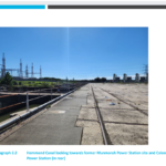
Munmorah Power Station did not require development consent when it was constructed in the 1960s but its land owners now need development approval to remediate contamination on the site. They expect the site will soon be declared significantly contaminated land under the Contaminated Land Management Act 1997. A development proposal now on public exhibition outlines the “legacy” … [Read more...] about Plan to deal with contamination at Munmorah power station site
Latest News
Gosford Bowling Club on borrowed time
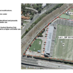
Gosford Bowling Club, classified as community land, is to go through a process to change it to operational land, opening the way for council to sell it. At a media briefing on August 17, the CEO David Farmer made it clear the council believes the land could be better utilised. And council doesn't want to own the land long term. The council will engage with the bowling … [Read more...] about Gosford Bowling Club on borrowed time
Learn how to comment on development proposals

Understand the building approval process as it goes through Council. A free introductory Workshop on Council Planning being held by the Peninsula Residents Association at Everglades Country Club on August 27. Formed in 2021, the Peninsula Residents Association seeks to give a collective, non partisan community voice on matters concerning liveability and the environment on the … [Read more...] about Learn how to comment on development proposals
Petition aims to save Wamberal from a seawall
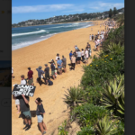
A petition calling for a halt to Council-under-administration’s plans to build a seawall at Wamberal Beach is now live on the State Parliament’s website. Abigail Boyd MLC (Member of the Legislative Council), a Terrigal resident who has followed the seawall issue for years, has sponsored Wamberal Beach Save Our Sand’s petition. “We must listen to the evidence and to the … [Read more...] about Petition aims to save Wamberal from a seawall
App maps potential impact of floods
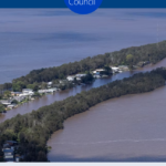
Council-under-administration has released a flood map for Tuggerah lakes. The interactive online flood mapping tool for Lake Munmorah, Budgewoi Lake and Tuggerah Lake, draws on current and predicted flood levels directly from the Bureau of Meteorology and converts it into a visual display to show the extent of flooding. You can search your property, and see the impacts of … [Read more...] about App maps potential impact of floods